What Does The Sky Look Like Before A Tornado
What does the sky look like before a tornado? If you’ve ever wondered about this, you’re not alone. Tornadoes are powerful and destructive natural phenomena, and understanding the signs of their approach can be crucial for staying safe. In this article, we will explore the visual cues that may indicate the presence of an impending tornado. So, let’s dive in and unravel the mysteries of the sky before a tornado strikes.
The Eerie Stillness:
One of the first things you may notice before a tornado is the eerie stillness in the air. This calmness can be deceptive, as it contrasts with the turbulent conditions about to unfold. The absence of wind is a result of the storm’s updraft overpowering the normal flow of air. It’s as if nature is holding its breath before the storm unleashes its ferocity.
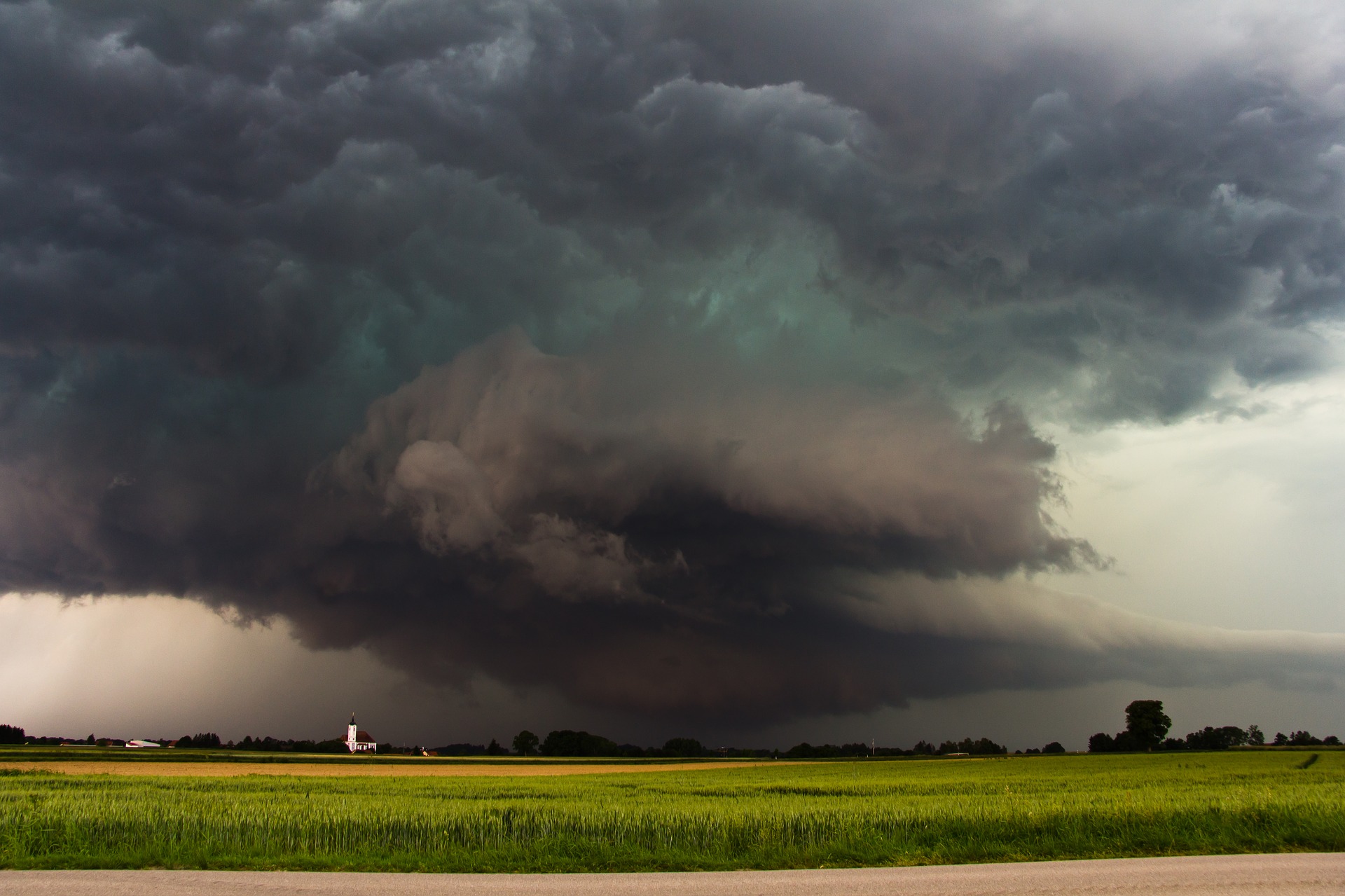
The Greenish Hue:
Another striking aspect of the sky before a tornado is its greenish tinge. This peculiar coloration occurs due to the interaction of sunlight with the storm clouds. The green hue is a result of light being filtered through the storm’s moisture-laden atmosphere, where water droplets scatter and reflect shorter wavelengths of light, leaving a greenish impression.
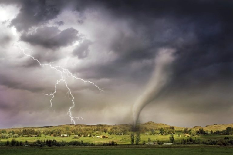
Dark and Brooding Clouds:
As a tornado approaches, the sky becomes filled with dark and brooding clouds. These towering thunderstorm clouds, known as cumulonimbus clouds, are indicative of the severe weather conditions that often accompany tornadoes. The clouds can appear menacing and foreboding, stretching high into the atmosphere and casting an imposing shadow over the land below.
Wall Clouds:
One of the most prominent visual indicators of an approaching tornado is the formation of a wall cloud. This is a low-level, rotating cloud that hangs beneath the main storm structure. Wall clouds are typically large, dark, and often exhibit rapid motion. If you notice a wall cloud forming or descending from a thunderstorm, it is crucial to take immediate shelter as it could be a precursor to a tornado touchdown.
Mammatus Clouds:
In some cases, the sky before a tornado may exhibit an unusual cloud formation called Mammatus clouds. These are bulbous, pouch-like structures that typically form on the underside of cumulonimbus clouds. The presence of mammatus clouds can indicate the presence of severe instability in the atmosphere, which can contribute to the formation of tornadoes.
Curtain-like Precipitation:
Another telltale sign of an impending tornado is the appearance of curtain-like precipitation. As a supercell thunderstorm intensifies, you may observe a curtain-like or cascading effect of heavy rain and hail falling from the storm cloud. This visual phenomenon is a result of the strong updrafts and downdrafts within the storm, creating a turbulent motion of precipitation.
The Roar of the Beast:
Although not a visual cue, the roar of an approaching tornado is worth mentioning. When a tornado is nearby, you may hear a loud, continuous roar, akin to a freight train or a jet engine. This sound is generated by the powerful winds and the motion of debris carried within the tornado. If you hear this unmistakable sound, seek shelter immediately.
Frequently Asked Questions:
Now, let’s address some common questions about what the sky looks like before a tornado:
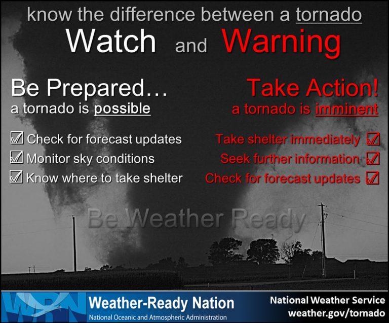
Q: Are there always visual signs before a tornado?
A: While certain visual cues can indicate the presence of a tornado, it is important to note that not all tornadoes will exhibit the same characteristics. Some tornadoes may not display any visible signs until they are very close or on the ground. It is crucial to have multiple sources of information, such as weather alerts and radar, to stay informed about severe weather conditions.
Q: Can a tornado occur without the sky looking different?
A: Yes, tornadoes can occur without significant changes in the appearance of the sky. Weather conditions can vary, and some tornadoes may form in situations where the visual cues are less pronounced. This is why it is vital to rely on various sources of information and stay vigilant during severe weather.
Q: Can the color of the sky predict the severity of a tornado?
A: While a greenish sky can indicate the potential for severe weather, it does not directly correlate with the intensity or severity of a tornado. Tornadoes can range from weak to violent, regardless of the sky’s color. It is essential to prioritize safety measures and heed official warnings, regardless of the sky’s appearance.
Final Thoughts:
Understanding the visual indicators of an impending tornado can help you stay alert and take appropriate actions to protect yourself and your loved ones. However, it is essential to remember that these signs are not foolproof, and relying solely on visual cues can be risky. Always stay informed through reliable sources like weather forecasts and emergency alerts, and have a safety plan in place for severe weather events. By being prepared and staying aware, you can increase your chances of staying safe during tornadoes and other severe storms.